FAQ
AirScape: Revolutionising Air Quality Monitoring
The world’s first hyper-local air quality sensor network fundamentally transforms how we monitor and manage air pollution to improve public health and well-being in urban spaces.
Capable of monitoring up to seven pollutants, along with temperature and humidity, this advanced network generates high-resolution data, providing a detailed street-by-street analysis of air quality. AirScape’s scalability and customisation make it suitable for a diverse range of users, from individuals to large organisations, including government departments at both local and national levels.
The AirScape platform is free and available to everyone, providing valuable insights to enable informed decisions to protect public health.
This FAQ page covers topics such as how the platform works, the choice of Camden as the first site, plans for future projects, the impact on local community and businesses, benefits of airscape.ai compared to other air quality monitoring platforms and how to get involved.
If your question isn’t answered here, please get in touch
AirScape is a revolutionary new approach to monitoring air pollution. It is designed for anyone who wants to track air pollution levels, from individuals concerned about their health to businesses, cities, and governments looking to manage air quality. The platform is scalable and can be customised to meet the needs of different users, from individuals to large organisations in different regions and environments.
The first installation in Camden acts as a blueprint for other boroughs and cities to follow in order to truly understand and tackle the air pollution crisis. AirScape has installed 229 advanced air quality sensors in the London Borough of Camden, to make it one of the world’s densest fixed sensor network. The network provides at least 45x more data points and refreshes 60x more regularly than existing air quality referencing stations, providing a street-by-street picture of air quality in real time. The installation in Camden is a blueprint for other boroughs and cities to follow in order to truly understand and tackle the air pollution crisis.
airscape.ai is a web-based map platform giving free access to that data in a user-friendly way. It provides comprehensive and accurate data on air quality, allowing users to make informed decisions to protect their health.
The AirScape system consists of state-of-the-art, science-grade air quality sensor devices called AirNodesTM. These AirNodes have been developed in our Research Lab in Copenhagen and are designed to meet the stringent requirements of the CEN /TC 264 “Air Quality Measurement” standard. Supported with advanced remote calibration, the accuracy of the measurements made by each AirNode are ensured to meet this CEN standard.
The AirNodes take high-quality measurements of PM1, PM2.5, PM4, PM10, nitrogen dioxide (NO2), ozone (O3), carbon monoxide (CO), carbon dioxide (CO2), temperature and humidity.
Data gathered from the AirNodes provides a high-resolution, real-time picture of air quality at a local level, not just isolated snapshots.
AirScape’ ambition is to install networks in every major city around the world, to enable a step-change in how air pollution is understood and addressed. Camden is the borough where AirScape will prove the concept and create the blueprint for other London boroughs and cities around the world to follow. AirScape is already in advanced discussions with other London boroughs, city authorities and communities seeking to have AirScape in their areas.
The local community can see the complete picture of air quality in Camden for the first time and track how it changes over time. They can drill into more detail for specific locations and compare different places and at different times of the day. The hyper-local information is available on an easy-to-use platform, free of charge. Allowing for the data to be accessible to the public is a crucial step to increasing community engagement with this important topic. Community groups use the data to inform their walking and cycling routes around the borough.
We have collaborated closely with responsible businesses that are interested in supporting the local community and improving air quality where their staff and customers live. Businesses have a duty of care to their employees to provide a safe working environment and the AirScape initiative offers a tangible demonstration of social value and sustainability. The project has been well received by local businesses, who are open to using the information to help protect their staff and customers from air pollution.
Firstly, it provides reliable data that is updated in real-time, allowing users to make informed decisions about their health and safety. Secondly, airscape.ai is a scalable platform that can be customised to meet the needs of different users, from individuals to large organisations. Thirdly, it offers a range of advanced features such as route planning, predictive analytics and alerts that provide valuable insights and helps users take proactive measures to improve air quality.
Businesses, individuals and the local community can sponsor an AirNode to support the set-up and operation of the physical network. Members of the public can also engage with and share the data among friends and community members to keep air quality high on the agenda and encourage action to improve it.
The data platform and interactive map are freely accessible to all. AirScape will be launching a premium version which will provide more comprehensive analytics which can be used by local organisations.
The cost of building airscape.ai in your city or community depends on the size of the network and the features you require. We offer flexible pricing plans for businesses and governments, and you can contact the airscape.ai team for more information on pricing and options.
There are a number of different revenue streams available to install an AirScape network. These include corporate sponsors looking for a CSR boost, local government, business and community sponsorship of individual AirNodes and major global partners using AirScape as an API for their maps platforms.
Each AirNode undergoes a rigorous calibration process. This is initially carried out in a laboratory setting against scientific grade equipment for quality assurance and to derive initial calibration parameters, before they are tested on location. In the field, AirScape co-locates some AirNodes with local authority reference stations to ensure AirNodes maintain accurate readings.
AirScape works with professional contractors to install and maintain the devices on public and private assets. They work closely with asset owners, including councils for street lighting columns, to make sure the installation phase is an easy and seamless process. Attachment is non-destructive and only requires access to a nearby power source.
The AirNode reports detailed air quality measurements minute-by-minute to the AirScape data management system. Together the AirNode network and sophisticated data analysis algorithms of the AirScape data management system capture and identify pollution hot spots, at a localised level, and provide comprehensive analysis and visualisation to enable deployment, management and optimisation of pollution-lowering initiatives.
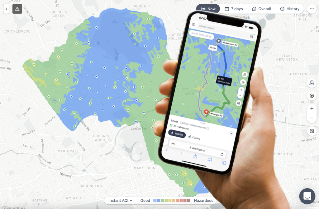
Visit AirScape.ai, where you can view the air pollution map. The map can be filtered to look at overall air quality, PM2.5, PM10, O3 and NO2 and can be viewed in real time, the last hour or 24 hours, 7 or 30 days or since the platform was launched.
The platform is designed to be user-friendly and easy to navigate, with customisable features, such as a route planner and real-time alerts to keep you informed about air quality conditions.
PM2.5, PM10, O3 and NO2.
We can also measure sulphur dioxide, HC, carbon dioxide, and carbon monoxide, as well as weather conditions and other environmental factors that impact air quality.
The AirScape network is more densely spaced than rival networks and produces 10,000x more data points per km2 than current air quality reference station networks, to provide hyper-local information.
What sets AirScape apart is that the data is publicly available via an easy-to-access map platform on airscape.ai. Making the invisible visible, this enables a step change in terms of action – to empower local people, community groups, businesses, and local authorities to take transparent, measurable action to tackle the air pollution crisis and reduce exposure.
It also enables local authorities and local people to track the effectiveness of their actions to ensure informed policy-making and effective use of taxpayer money.
The first step in tackling air pollution is understanding it. By providing a hyper-local, real-time picture of air quality, policymakers, businesses and the local community will be able to identify clear trends in air pollution spikes across the area to identify core causes and explore the measures needed to mitigate it.
The data can be used to inform:
- routes to and from school or work.
- where and when to exercise.
- when to wear protective masks
- when to avoid spending time in high-pollution areas
- where to buy a house or rent premises.
- which modes of transport individuals and employees should use to move from A to B.
- when employees should work from home due to high air pollution.
- policy decisions and infrastructure changes, such as the installation of green walls, road closures and the introduction of new cycle lanes.
- where key pollution hotspots are, such as factories or construction sites, and how they can be tackled.
The early data on the platform shows significant variance in the levels of air pollution from one hour to the next and street by street. For example, we see changes of >60 ug/m3 over distances of less than 100 m. It is by understanding the nuance of these findings that local people and community groups can make informed decisions to reduce their exposure to air pollution.
AirScape is hosted on a web app which is easy to use on desktop, mobiles and tablets. There are no immediate plans to launch an app, but AirScape may develop one in future.
The AirScape platform has been built with API capability, so we see huge potential in partnering with big tech companies to democratise the challenges and solutions to air pollution – enabling people all over the world to tackle what is one of the world’s biggest public health challenges.
Please contact the AirScape team at airscape.ai/home for more information, or to schedule a demo or consultation.